Presence
journal
special issue on Virtual Heritage
MIT Press
15.3, June 2006
Aspen the Verb: Musings on Heritage and Virtuality
Michael Naimark
Abstract
Aspen, the picturesque mountain town in Colorado,
is known for two processes, or "verbs," relating to heritage and
virtuality. One is to "moviemap," the process of rigorously filming
path and turn sequences to simulate interactive travel and to use
as a spatial interface for a multimedia database. The other is to
"Aspenize," the process by which a fragile cultural ecosystem is
disrupted by tourism and growth. This essay reflects on their significance
and describes exemplar work integrating these two seemingly disparate
concepts."
Introduction
It's July, 2003, and I'm back in Aspen. Actually
not in town, but in Missouri Heights just above El Jebel, the small
town a half-hour drive "down-valley" from Aspen, at my sister Judy
and her family's home. Judy is a local, having visited Aspen in
the early 1970s and stayed. Like many of her friends who also stayed,
she eventually married, had children, and moved down-valley. Real
estate ads in this week's Aspen Times list Aspen homes beginning
at $2 million and going upwards of $10 million.
My first time in Aspen was 25 years ago, filming,
of sorts. Several pulse-frame motion picture cameras were configured
panoramically on top of a jeep and triggered by a fifth wheel trailing
from the rear. We were filming one frame every ten feet, driving
up and down every street in town and through every intersection
every possible way.
That Judy lived in Aspen then was roughly Reason
Number Four why a small group of MIT researchers, myself included,
chose Aspen, Colorado, as the test bed for a new form of interactive
experience. Judy worked at "Aspen State Teacher's College," not
a college at all but a local prank and small business selling t-shirts,
mugs, and other college paraphernalia to tourists, mostly skiers
and hikers. Judy's local knowledge would be useful for production,
it was concluded. The other two reasons were that Robert Mohl, another
MIT researcher, grew up in Colorado and had professional photography
experience around Aspen; and that the nascent Aspen Design Conference
would be a befitting venue for presenting the project when it was
completed.
Whoops, did I forget Reason Number One? Simply
- because it was Aspen, a intensely beautiful mountain town with
a single traffic light and a lively local community. Why fib? Aspen
was a cool place and we all wanted to go.
The Aspen Moviemap - Place Representation
The Aspen Moviemap was the first interactive
"virtual travel" project to incorporate photo-realistic images via
computer-controlled videodisc. The project, which began in 1978,
originated at MIT's Architecture Machine Group, Nicholas Negroponte's
proto Media Lab. Andrew Lippman, already a long-time colleague of
Nicholas', was the Principal Investigator. Funding came from DARPA's
Cybernetics Technology Office, headed at the time by Craig Fields,
who had already supported other projects relating to visual mapping.
The Aspen Moviemap was an academic, non-commercial, non-classified
project.
"Its goal was to create so immersive and realistic
a 'first visit' that newcomers would literally feel at home, or
that they had been there before," recalls Andy Lippman. "DARPA realized
the need after Israeli soldiers practiced for the recovery of an
airplane hijacked to Entebbe by using an abandoned airfield made
up to look similar" (Lippman, 2004)
The optical videodisc was a revolutionary technology
then. Remember, if you can, 1978: 16mm film was the primary medium
for all television news gathering; video editing was barely computerized;
and storing moving pictures in computer memory was ten years away.
The optical videodisc was capable of storing a half-hour of analog
video (54,000 frames) and two-channel audio, with instant access
to all the material via computer control. In early 1978, "ArcMac"
received one of the first twenty-five prototype videodisc players
from the MCA Corporation, and with it a contract to master three
discs of its own.
That Spring, an energetic MIT undergraduate named
Peter Clay proposed "mapping" the hallways of MIT by mounting a
16mm film camera capable of shooting single frames on a dolly tripod,
then wheeling it down the hallways triggering one frame every step
he took. With the help of graduate students Bob Mohl and me, Peter
shot the hallways. The footage was included on the "B-side" of the
"Slidathon" disc, MIT's first laserdisc. Peter and Bob made a simple
computer program that allowed control of speed and direction moving
up and down the hallways. Voila! "Virtual travel."
That Fall, then again in the Winter, a small
squadron from MIT descended upon Aspen to make a "sweep," under
the general direction of Nicholas, Andy, and Craig. The camera rig
on the jeep was designed and operated by wildlife cinematographer
John Borden, MIT undergraduate student Stan Syzaki, and me. Its
footage was conceived as a backbone on which a comprehensive audiovisual
survey of Aspen could be spatially organized. This survey included
"micro-documentaries" by MIT Film/Video professor Richard Leacock;
binaural sound collected by ArcMac faculty Steve Gregory and graduate
student Rebecca Allen; tens of thousands of still frames, including
of every building facade in town, shot in summer and in winter,
and historical images re-photographed by ArcMac graduate student
Scott Fisher; non-audiovisual data (which we called "data data,"
e.g., cases of beer consumed per week and total number of beds),
collected by ArcMac graduate student Walter Bender; and overview
map ideas by UC Santa Cruz cognitive psychologist Kristina Hooper.
Bob Mohl, who went on to write his PhD dissertation on the Aspen
Moviemap, was everywhere. (Mohl, 1981)
A sweep like this is not inconspicuous - driving
down the center of the streets and photographing every facade -
and the Aspen townspeople were characteristically nonchalant about
our presence. Everyone, from the sheriff's office to store owners
to residents, was cooperative, if not amused.
The final project took shape back at the lab,
where the material was organized, edited, and mastered onto a videodisc.
The controlling software and interface design, with the additional
help of ArcMac graduate students including Steve Yelick, Paul Heckbert,
and Ken Carson, turned the mass of material into a singular virtual
travel experience. By Summer, 1979, the Aspen Moviemap was ready
for its first demo, and it caught the attention of the press.

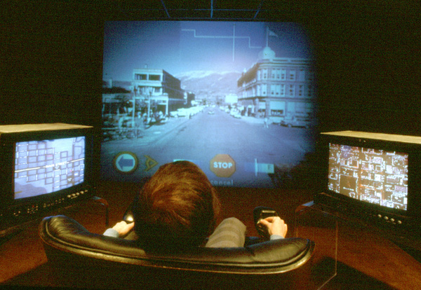
Figure
1: The Aspen Moviemap experienced in the "Media Room" at the Architecture
Machine Group, MIT, c1980. The "traveler," seated in an instrumented
armchair, controls speed and direction of travel. Touch screens
displaying map and aerial views allow access to additional multimedia
material. (Photo: Bob Mohl)
Moviemapping, it seemed at the time, was destined
to enjoy widespread popularity as a new medium for experiencing
place, for virtual travel and virtual tourism. The dream was that
popular tourist destinations, spectacular landscapes, sacred places,
and heritage sites could be moviemapped and appreciated by many
more people than could actually go there. It would be more experiential
than magazine photographs and linear television shows. Indeed, it
was most often referred to as "surrogate travel."
Several participants from the original Aspen
team went on in various permutations to moviemap Paris for the Paris
Metro (1985), Palenque for the Bank Street College (1985), San Francisco
for the Exploratorium (1987), Karlsruhe Germany for the Center for
Arts and Media (ZKM) (1990), and Banff for the Banff Centre for
the Arts (1993). (Naimark, 1997)
The concept of community "sweeps," often with
the participation of locals and students, continued. In the early
1990s, the Apple Multimedia Lab organized a one-day sweep of Moss
Landing, a small California coastal village. In the mid 1990s, the
UC Berkeley Center for Design Visualization and the UNESCO World
Heritage Centre led groups to sweep various cultural heritage regions
in Europe. New digital technologies for capture, modeling, and display
add greater possibility and practicality to moviemapping.
Moviemap - the verb - made Aspen an exemplar
of what place representation using new media technologies can be.
Aspenization - Place Control
But the verb more popularly associated with Aspen than "to moviemap" describes something else. To "Aspenize," says one longtime Aspen public official, is when small towns "choke on what their charm has brought them." Aspen has become the poster town for this process, and its emblematic image is a mountain landscape foregrounded by an airport full of private jets.

Figure
2: "Traffic jam" of private jets at the Aspen Airport. (Photo: Paul
Conrad, The Aspen Times)
The word "Aspenization" first appeared nationally
in a 1993 Newsweek story about Crested Butte, another picturesque
Colorado mountain town:
A town [Crested Butte] with such attractions
is a natural target for what people in Colorado call Aspenization:
the upscale living death that fossilizes trendy communities from
Long Island's Hamptons to California's Lake Tahoe. Aspen was a splendid
place, too, before it was discovered by the rich and famous -- and
the greedy and entrepreneurial. Now it's a case study in overdevelopment.
Its lavish second homes sit empty for most of the year while three
quarters of the work force, who can't afford to live there, commute
from 40 miles down-valley -- a two-hour trek at rush hour. (Gates,
1993)
In 1998, the New York Times described Aspenization
and housing costs:
Welcome to Aspen, home of the most expensive
residential real estate in the nation. Last year, the typical home
here sold for $1.5 million -- 12 times the national average. ''Doctors
in Aspen are just blue-collar workers,'' said Mallory Harling, an
obstetrician-gynecologist who lives in public housing with his wife,
Karen. ... With ''Aspenization,'' a scare word in the region, the
saga of roaring real estate prices in Rocky Mountain resorts can
best be told in this silver mining town, built over a century ago
at the end of a box canyon, at the top of the Roaring Fork Valley. ... In 1996, a house at the base of Aspen Mountain sold for $9 million.
Last summer, a house atop Red Mountain sold for $19.7 million. This
spring a 67-acre ranch and house just outside town is on the market
for $24.8 million. Real estate agents sniff that $1 million will
buy only a ''fixer-upper.'' Elsewhere in town, rents are on a par
with New York City. ... ''Affordable housing is absolutely fundamental
to our efforts to keep Aspen real,'' said John Bennett, Aspen's
Mayor, who has seen about 70 percent of the city's private housing
become vacation homes. ''We don't want to be just an empty theme
park, full of houses that are occupied only a few weeks out of the
year. We want to remain a real-life town, with living, breathing
people who have real jobs.'' ... Aspen residents joke that their town
is divided into two groups: people with three jobs, and people with
three houses. (Brooke, 1998)
"Aspenization" has since been used to describe
growth and development in towns from Santa Fe to Whistler and from
Hawaii to New Zealand.
For better and for worse, Aspen has earned this
transformation into a verb. The Aspen locals have a long and spicy
history of trying to maintain control of their community. In 1969,
"gonzo" journalist and Aspen local Hunter S. Thompson co-founded
the "Freak Power" party. Its mayoral candidate Joe Edwards ran on
an anti-development platform that included, among other things,
replacing the paved roads with sod to slow down development. Edwards
lost by six votes. The following year Thompson ran for sheriff of
Pitkin County, the much larger region, and lost by 500 votes. If
ever there were "tipping points" in the history of US anti-development
movements, these Aspen elections may have been as close as it came.
But Aspenization isn't simply about being anti-wealth.
Sister Judy: "The rich used to come here and wear flannel shirts
and jeans." Adds Michael Kinsley, Pitkin County Commissioner in
Aspen in the 1970s, "there was an unspoken ethic here that the rich
had to look and act like everyone else. Aspen was one of the few
places where Jack Nicholson or Goldie Hawn could walk down the streets
and nobody cared." (Kinsley, 2003)
Aspenize - the verb - made Aspen an exemplar
of what happens when local custodians lose control of the place.
Representation Equals Control
That Aspen spawned the both Moviemap and Aspenization
is noteworthy for several reasons. First, issues surrounding place
representation, as exemplified by the Moviemap, and issues surrounding
place control, as exemplified by Aspenization, are two of the most
prominent issues surrounding heritage sites. Second, these two professional
communities tend to be of different cultures and rarely interact:
they drink in different bars. Finally, evidence suggests that representation
and control are deeply interconnected.
Consider the work of UC Berkeley Geography Professor
Bernard Nietschmann. His early fieldwork in the 1960s was on the
Caribbean coast of Nicaragua working with the Miskito, Sumo, and
Rama Indians. In the early 1980s, reports of relocation and murder
of coastal Indians by the Sandinistas compelled Nietschmann to see
for himself, and he went in "unofficially." Nietschmann, who at
the time was Chair of the UCB Geography Department, was the first
American in this region during the conflict, and he returned not
shy about taking an aggressive pro-indigenous stance. His 1984 article
in Co-Evolution Quarterly journal, with his ample use of the phrase
"Miskito Indian Warriors," received the highest number of angry
reader responses in the journal's history. CQ assigned another writer
to go to Nicaragua for a second opinion. (Nietschmann, 1984) (Baker,
1985)
Eleven years later, Nietschmann published another
report, in Harvard's Cultural Survival journal, outlining a different
paradigm, of making maps instead of using guns. Using portable Global
Positioning Satellite (GPS) gear, Nietschmann worked with local
Miskito teams to re-map their territory. In 1991, as a direct result,
the Nicaraguan government created a 4,000 square mile Miskito Coast
Protected Area, under the control of the Miskito people. (Nietschmann,
1995)
In the mid-1990s, Nietschmann was invited by
42 Maya villages in southern Belize to help them map their own territory,
to win a Belize Supreme Court battle against corporate land use.
In 1997, the villages collectively authored the "Maya Atlas." The
Atlas has become an important educational and legal instrument,
as well as an aesthetically vibrant "coffee table" book. (Toledo
Maya Cultural Council, 1997)

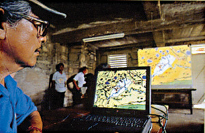
Figure 3: "Media Room" set up for production of the Maya Atlas in
the basement of the church, San Antonio, Belize. (Photo: Bernard
Q. Nietschmann)
Nietschmann summed things up succinctly: "Maps
are power. Either you will map or you will be mapped." (Nietschmann,
1997)
As we move forward with our powerful new tools
for place representation and virtual heritage, the questions remain
"by who?" and "for who?" With travel and tourism representing 10%
of the global economy, there's a lot at stake to get it right. But
it's painfully easy for the outside holders of the technology, rather
than the local providers of the content, to set the rules. Without
balance and cooperation between both, the loss will be everyone's,
particularly ours.
Acknowledgements
A colleague once joked that if everyone who claimed
to have worked on the Aspen Moviemap were to convene for a reunion,
it would have to be held in Denver because Aspen is too small. I
gratefully acknowledge the review and fact-checking of the Moviemap
text by Andy Lippman and Bob Mohl.
I also gratefully acknowledge New York Times
writer Jim Brooke, former
Pitkin County Commissioner Michael Kinsley, and Judy Naimark Sullivan
for their help. I also thank Ed Bastion, Hunter Thompson's Campaign
Manager in 1970, for confirming details directly with Mr. Thompson
for this essay; and Paul Conrad and The Aspen Times for use of the
photograph.
Bernard Nietschmann was a longtime mentor and
personal friend. Once, on a boat with Barney on the Rio San Juan
in Nicaragua, I made the very dumb mistake of referring to our location
as the "middle of nowhere." He blew up at me and screamed "What
is nowhere?!? There is NO nowhere!" Barney, who died in 2000, was
uniquely gifted at bridging cultures.
References
Baker, W. (1985). "Izum in Rindydinkaragua."
Whole Earth Review [formerly CQ], No. 46.
Brooke J. (1998). "Subsidies for High-Income
Families." New York Times, May 17, 1998.
Gates D. (1993). "Chic Comes to Crested Butte."
Newsweek, December 27,1993.
Kinsley M. (2003). Telephone interview, 24 July
2003.
Lippman A. (1980)."Movie-maps: An application of the optical videodisc to computer graphics." ACM Siggraph Proceedings, 1980.
Lippman A. (2004). Personal email, 29 October
2004.
Mohl R. (1981) "Cognitive Space in the Interactive
Movie Map: An Investigation of Spatial Learning in Virtual Environments."
PhD dissertation, Education and Media Technology, M.I.T.
Naimark M. (1997). "A 3D Moviemap and a 3D Panorama."
SPIE, 3012.
Nietschmann, B. Q. (1984). "Nicaragua's Other
War." Co-Evolution Quarterly, No. 41.
Nietschmann, B. Q. (1995). "Defending the Miskito
Reefs with Maps and GPS: Mapping With Sail, Scuba and Satellite."
Cultural Survival Quarterly, Vol. 18, No. 4.
Nietschmann, B. Q. (1997). "The Making of the
Maya Atlas," in Maya Atlas, pp. 136-149, North Atlantic Books,
Berkeley, CA.
Toledo Maya Cultural Council and the Toledo Alcaldes
Association (1997). Maya Atlas. North Atlantic Books, Berkeley,
CA.
|